

Rick Thompson’s
Lake Missoula Flood Research
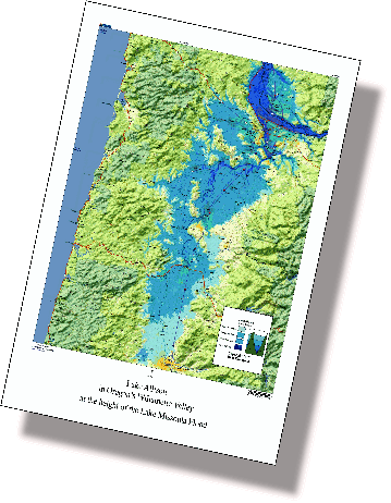
Rick spent over 3 years painstakingly tracing the water levels to make this Lake Allison Map
Rick Thompson's Research in Portland, Oregon; Vancouver, Washington; and the Willamette Valley, Oregon
It has been written that there is not much to see of the Lake Missoula Floods in Oregon. My research shows that there is plenty to see once we know where to look and what to look for. I concentrate on the largest of the floods, the GigaFlood, because it did the most to reshape the land.
This flood tore through the Columbia River Gorge, shaping Beacon Rock, carving the cliffs at Cape Horn and overtopping Crown Point.
It next shot between Woodburn Hill and Prune Hill in the area of Camas, Washington, scooping out what is now Lacamas Lake and literally filling the Vancouver basin with rocks, gravel and sand all the way from Camas to LaCenter.
South of where the Columbia now flows the GigaFlood carved the sides off of Rocky Butte and other East Portland volcanoes, left gravel bars as high as 300 feet and as much as 11 miles long. Between the buttes it cut channels that are now the pathways for highways, streets, bicycle and walking trails.
When it was impounded, possibly by an ice log jam, near Kalama, Washington, it flooded south as far as Eugene, Oregon, cutting channels like Lake Oswego, Carver Gap and the Oregon City gap leaving tons of sediment and erratic boulders that had ridden in on icebergs which were later documented to have dotted the shores of the temporary lake. Geologists have name this Lake Allison after an early 20th century geologist who did much research and on the Willamette Valley.
The Lake Allison map, on the right, shows the water depths in 100 foot increments during the height of the GigaFlood.