
Photos and More
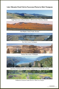
Lake Missoula Flood Path
Print & Map - 11” x 17” - $12.00
This 11"x17" print captures a glimpse of the immensity of this great event with seven color panorama photographs that highlight some of the most significant sights from Montana, Idaho, Washington and Oregon. Also on the back is a map of the path, indicating where each photo was taken, a brief story of the flood and a thumbnail of each photo with detailed information about that site.
This interpretive and educational print for all ages is excellent for gift shops, schools, science and geology classes or clubs.
Contact us at info@Gigaflood.com for wholesale quantity and pricing.
Six panorama photographs showing the path of the Lake Missoula Flood as it tore across four states.
Mt. Sentinel in Missoula, Montana; Camas Prairie, Montana; Dry Falls and Palouse Falls in Washington; Columbia River Gorge; and Camassia Nature Preserve in West Linn, Oregon; the only scabland west of the Cascades. This beautiful glossy photo-paper series of panorama photographs is not only a treasure for those interested in the Missoula Flood but also a wonderful visual aid for those teaching about the flood.
Lake Missoula Flood Path in Panorama 16” x 24” - $24.00